


TRIPS
Top Arctic World Expeditions

Recommended video

Outstanding News

Travel Map

IPGA Association

Specialists in Iceland

What does GPS display at the Geographic North Pole?


What does GPS display at the Geographic North Pole?
The Geographic North Pole is situated at the northern tip of the imaginary axis of Earth rotation. a remote spot in the middle of the Arctic Ocean where all terrestrial meridians come together and which geographical latitude is 90° North.
This mythical point that captivated the mind and soul of entire nations in the golden age of polar exploration, is the only place on the planet where all directions are south.
So, if all terrestrial meridians coincide in the Geographic North Pole ¿What does GPS display on the "top" of the world?
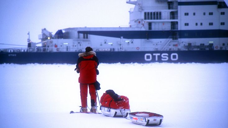
The answer can be seen in a practical way in the pictures of this article taken during the first Argentinian expedition on skis to Geographic North Pole led by Jose Naranjo and whose logistic organization was carried out by Arctic World.
The second photo shows that the GPS latitude is 89º 59' 59.9" North. Then, Could we say that we are in the Geographic North Pole? Technically not because the Geographic North Pole is located at 90° 00'00,0" north latitude. That is to say that at the time the photo was taken the GPS was only one tenth of a sexagesimal second (about 3 meters in a straight line) from the geographic North Pole, but we were not yet at the exact point of the Earth's rotation axis.
In the fourth image we can see the GPS displays 90º 00' 00.0" North latitude, i.e. the latitude of the Geographic North Pole. And the geographical longitude is 46º 11' 39.1" East, which would be also the geographical longitude of northern Russia, Middle East and East Africa.
In the fifth picture we can see on the GPS screen that the latitude is 90º 00' 00.0" North and the longitude is 11º 19' 56.3" West, roughly corresponding to the geographical longitude of Northeast Greenland, North Atlantic Ocean, Western Sahara and East Africa.
We have gone from stepping on a geographical longitude over the Middle East to other over East Greenland in just few minutes!!
So, if at the exact point of the Geographic North Pole is where meet all the terrestrial meridians and therefore all geographical longitudes, Should the GPS displays a certain longitude?
The answer is in the last picture.
As can be seen in that image, the GPS becomes literally crazy because it cannot decide which geographical longitude has to be displayed on the screen, because on the very Geographic North Pole are all of them simultaneously.
On the "Big nail of the world" as the ancient Inuit called the Geographic North Pole, the GPS shows a flat "encephalogram", so to speak, and it doesn't display any position, just a series of lines where supposedly degrees, minutes and seconds should appear.
In fact our "beloved" electronic companion when positioned exactly on the Geographic North Pole is not even able to discern if the longitude is East or West or if the latitude is North or South.
Images: Tomas Heinrich and Jose Naranjo
This mythical point that captivated the mind and soul of entire nations in the golden age of polar exploration, is the only place on the planet where all directions are south.
So, if all terrestrial meridians coincide in the Geographic North Pole ¿What does GPS display on the "top" of the world?
The answer can be seen in a practical way in the pictures of this article taken during the first Argentinian expedition on skis to Geographic North Pole led by Jose Naranjo and whose logistic organization was carried out by Arctic World.
The second photo shows that the GPS latitude is 89º 59' 59.9" North. Then, Could we say that we are in the Geographic North Pole? Technically not because the Geographic North Pole is located at 90° 00'00,0" north latitude. That is to say that at the time the photo was taken the GPS was only one tenth of a sexagesimal second (about 3 meters in a straight line) from the geographic North Pole, but we were not yet at the exact point of the Earth's rotation axis.
In the fourth image we can see the GPS displays 90º 00' 00.0" North latitude, i.e. the latitude of the Geographic North Pole. And the geographical longitude is 46º 11' 39.1" East, which would be also the geographical longitude of northern Russia, Middle East and East Africa.
In the fifth picture we can see on the GPS screen that the latitude is 90º 00' 00.0" North and the longitude is 11º 19' 56.3" West, roughly corresponding to the geographical longitude of Northeast Greenland, North Atlantic Ocean, Western Sahara and East Africa.
We have gone from stepping on a geographical longitude over the Middle East to other over East Greenland in just few minutes!!
So, if at the exact point of the Geographic North Pole is where meet all the terrestrial meridians and therefore all geographical longitudes, Should the GPS displays a certain longitude?
The answer is in the last picture.
As can be seen in that image, the GPS becomes literally crazy because it cannot decide which geographical longitude has to be displayed on the screen, because on the very Geographic North Pole are all of them simultaneously.
On the "Big nail of the world" as the ancient Inuit called the Geographic North Pole, the GPS shows a flat "encephalogram", so to speak, and it doesn't display any position, just a series of lines where supposedly degrees, minutes and seconds should appear.
In fact our "beloved" electronic companion when positioned exactly on the Geographic North Pole is not even able to discern if the longitude is East or West or if the latitude is North or South.
Images: Tomas Heinrich and Jose Naranjo
Share this page in social networks


Do you like?